Kuari Pass is a high altitude (~13500 feet) pass in central Garhwal of Indian Himalaya. This trek is also popular by the name of Curzon’s Trail. In 1905 the Governor General of British India Lord Curzon crossed this pass and since then this route is also popular amongst trekkers especially foreigners as the Curzon’s trail. Nothing much has changed in these areas since Lord Curzon undertook this trek. The main attractions of this trek are the Twin Peaks of Hati and Ghodi parvat, the majestic Nanda Devi, Kamet, Dronagiri, Kedarnath, and Chaukhamba all arranged in a splendid arc. Apart from the peaks of Garhwal this trek also offers to the trekker the beautiful bugyals of Gurson and Sartoli, the company of peace loving mountain people of remote villages of Pana and Jhinjhi and the classy hill station of Auli. You will find the standard itinerary and required details on trek details for Kuari Pass on Curzon’s trail page. Also one may take short detour to reach the hot spring of Tapovan or the holy shrine of Badrinath from Joshimath
I started from Kolkata on 25th May and reached Haridwar on 26th. Haridwar is the nearest rail head for this trek and is well connected with New Delhi. Next morning Snigdho and Anik joined us and soon we were off to Ghat which was to be the destination for the day.
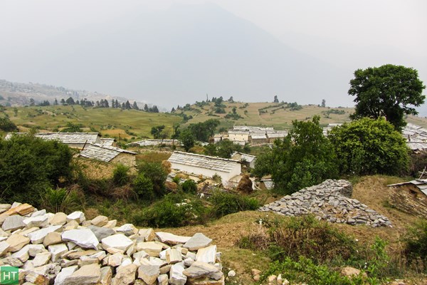
Note: Due to summer heat and wildfires in the lower altitude the skies were hazy most of the time. Tough luck for us with respect to the fantastic mountain and peak views which the trail offers.
Day 1: Haridwar to Ghat 220 Km 11 hours, 4363 ft
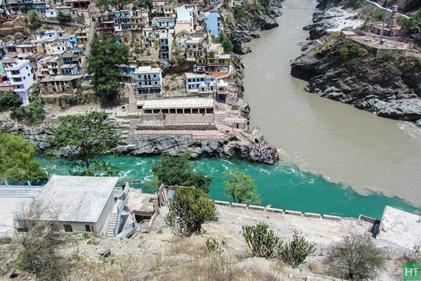
Ghat is 250 kms from Haridwar on the road to Badrinath. The road goes via Devprayag, Rudraprayag, Karnaprayag and Nandprayag, some of the most famous confluence of Garhwal Himalayas. We had breakfast on way to Rishikesh. From Nandprayag, the confluence of Alakananda and Nandakini one needs to take a different route to Ghat. The entire journey is along the Ganges in the beginning and after Devprayag you need to follow the road which goes alongside Alakananda River. At Srinagar Alakananda river widens to a broad and flat valley and is a convenient place to have lunch. From Karnaprayag we picked up Dev Singh our guide and porter Sheroo. We reached Ghat at around 7:00 in the evening and checked into a lodge. The river Nandakini passes through this village. The next day we were to go to Ramni the starting point for our trek to Kuari pass. Meanwhile Dev and Sapta made the final preparations for our trek to ensure all details were addressed. In this trail Ghat serves as the last point where you need to make all arrangements for ration and porters.
Day 2: Ghat to Ramni 3 hours, 6500 ft
From Ghat there is only one jeep service which goes to Ramni in the morning and the same jeep comes back to Ghat in the evening. We were ready and after having breakfast and packed all our equipment in the jeep. We started at 10:00 from Ghat. The road goes across the river and begins to climb the adjacent ridge in a circular path. Soon Ghat looks like a small village below. There is a trekking trail that ends at Ghat used by trekkers on the return from Ronti Saddle. This is a new road and previously trekkers had to trek to Ramni from Ghat village itself. There is also the option to start this trek from Ghuni village which is opposite to Ramni.
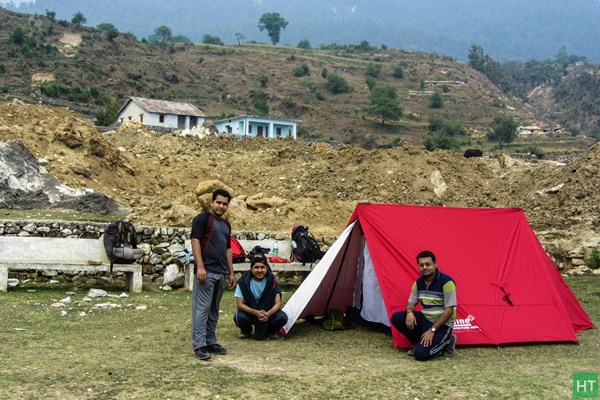
Camping at Ramni is done on the ground of the village school. Water is available besides the ground. We reached at around 1:00 pm and pitched our tents. It was to be my first experience of camping and as I was excited. Meanwhile our kitchen tent was ready and Dev and Sheero started preparing Kichdi for a quick lunch.
In the afternoon we took a stroll round the village of Ramni. The villagers are essentially a farming community, and grow potatoes, wheat and mustard for their daily needs. You do not find any tourists here. The village of Ghuni can be seen on the opposite ridge. Dev Singh showed us the trail for the next day over the top of the ridge behind us. We spent the evening by playing cards. Soon our dinner was ready and after dinner we went inside the comfort of sleeping bags.
Day 3: Ramni to Jhinjhi via Chechni Vinayak pass 6 hours, 5900 ft
Our mules had arrived by morning as arranged by Dev Singh from Ghuni village. 2 mules with their men were to accompany us on this trek. We had breakfast with roti, vegetables and halua and soon started to pack our camp. All the logistics were packed on the mules and we were off to our destination for the day. The trail begins to climb the ridge from the end of the campsite. The trail is paved by stones and can be well noticed. Soon we started to sweat and took off our windproof jackets. The trail passes through a few huts and enters the forests of oak. You can see the campsite and Ramni village gradually diminishing in size as you climb up.
It is common to find many abandoned shepherds huts while on the trail to Vinayak Pass. Water is scarce to find by on this stretch of the trek and so it is advisable to carry enough stock of water. The trail is tiring as the initial gradient becomes pretty steep and is a continuous uphill hike to the top called Chechni Vinayak pass at about 9000 feet. Continue with the trail in a series of switchbacks till Chechni Vinayak pass. It takes almost 3 hours to reach the pass. The pass is marked by a Ganesha temple with prayer flag. On a clear day one can see broad panorama of peaks from this top including Banderpunch, Chaukhamba, Neelkanth and others. From this point take right turn and follow the descending trail to the village of Jhinjhi passing through Ken Kharak.
The camping at Jhinjhi is at the other end of the village on the ground of the village school and one needs to cross the entire village bypassing the village huts. Finding water is never a problem here as there is a steady flow of water in the village from nearby streams. The faint roar of the Birahi Ganga can be heard from the campsite.
We arrived at around 2:00 exhausted. After having lunch with hot Maggie we went into tents to get some rest after the day’s exhaustion. Camping in the village draws the attention of the village kids and they cluster around the tents in small groups saying Namaste and asking for candies. We finished dinner by 8:30 and crashed into our sleeping bags.
Day 4: Jhinjhi to Pana 3 hours, 8500 ft
The dawn broke to a sunny morning and soon we started to get ready for the days trek to Pana. Dev and his team were busy preparing breakfast of roti and subzi. It was now time to bid farewell to Jhinjhi and descend to the bed of Birahi Ganga River originating from the famed Roopkund area. It is almost 2 km and 45 minutes descend and is steep at certain places. The initial trail passes through the farming grounds of Jhinjhi village and then goes under the cover of the forests of oak. The rocky trail is covered under dried leaves and is slippery. The sound from the campsite which seemed like a faint roar now begins to feel like thunder. Soon the hanging bridge over the river comes into view.
The river has carved out a deep gorge and flows deep beneath the bridge. The bridge sways when you walk over it. The bridge gives a good opportunity to enjoy the cool breeze and relax your muscles and prepare for the stiff climb to Pana. On the other side the trail rises steadily in a very steep gradient in a zig zag fashion for another 40 minutes. The steep trail gradually levels out on the top of the ridge and Birahi Ganga looks like a white thread in between two towering ridges. The trail now passes over almost level ground and rhododendron trees come into view. The sunlight filtered through the trees creates an amazing mosaic of light and shadow on the path. After 30 minutes the terraced slopes of Pana village comes into view.
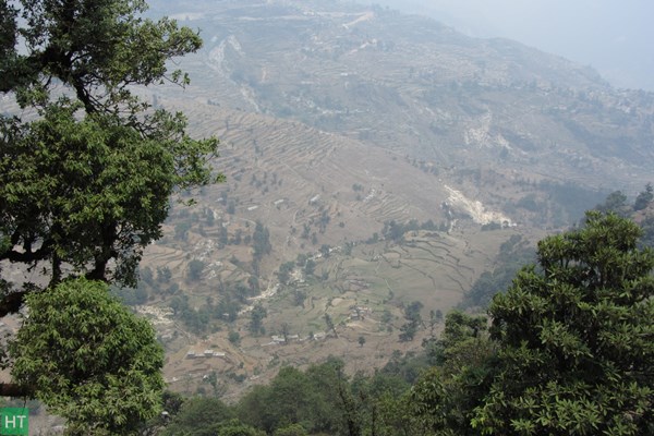
Continue on the gentle trail for another one hour enjoying the beauty of the forests. In front and slightly to your left lies the village of Pana, a bustling village on the ridge. It is surprising to find such a large settlement deep inside the Himalayas and miles away from any motor able roads. The trail bypasses the village begins to rise on the ridge. From here it is almost five hundred feet to the campsite above the village and takes another hour. The campsite is small. Look for some level ground to pitch tents. Though water is available here it is advisable to check in advance before planning to camp here. Advice from the locals on the trail can be of help. Alternatively one can also opt for a home stay in village of Pana.
We reached the campsite at 2:00 and were exhausted. Today trekking was not on high altitude and the heat was draining out all our energy reserves. We had lunch and took some rest. You can take a stroll around the campsite or make a visit to the settlement below. In the evening we lit a campfire and after dinner went off to sleep.
Day 5: Pana to Dakwani 7 hours, 11800 ft
Our destination for today was Dakwani at the foot of Kuari Pass. After breakfast we packed our bags and set off for Pana top. It is 2 km to the top of the ridge and is a moderate level hike and takes almost one hour. The advantage of camping above the village over the home stay is that you are already midway into the long hike to Pana top. We met a shepherd carrying his flock to the meadows for seasonal grazing. From the top of the ridge take right turn over level track through the forests of rhododendrons. The track ends into the vast open meadow of Sartoli which serves as a camping site as well as a good pasture ground for sheep and cattle. It is common to find shepherds with their flock dotting the landscape. From here Kuari pass can be seen in the distance dominating the horizon.
Relax on the gentle meadow after the long march from Pana. The trail from Sartoli gently climbs down through the forests. Follow the descending trail for a couple of kilometres to a place called Domabhiti. There is a small stream running down the slope and with a pool over it. The final descend to the pool is over a narrow path and very steep. The path is covered with scree and one needs to be careful on this stretch. A pair of walking stick comes very handy at this point. The stream provides a good opportunity to refill your water bottles. From this point there are two consecutive spell of steep ascends to be made of which the first is very steep indeed. Cross the stream over the concrete bridge and start to climb the steep trail in a series of switchbacks to the ridge top. Finally on the top of the ridge the trail flattens out and rhododendron trees abound everywhere. You are now at close to 10000 feet and can feel the cool breeze. From here the trail climbs gently through the rhododendron forests and goes past another stream. If you are doing this trek in the booming season (late April to Mid May) the entire forest lights up in a fiery red color. But at end of May all we could find was dead flowers. The forest also provides a good opportunity to spot birds. From here it is no more than 40 minutes to the campsite of Dakwani.
At Dakwani the tree line ends and the air becomes chilly. You need to be in heavy woollens here. It is a desolate place and you are in the company of shepherd and their flocks. Notice the trail to Kuari Pass climbing the ridge in a series of curves. Water is available on the trail to the pass from Dakwani. We had lunch with Maggie and soup. Meanwhile Dev and Sheroo started preparing dinner. The night was much colder here compared to last few days. We finished dinner and slept early hoping to start soon after sunrise the next day.
Day 6: Dakwani to Auli via Kuari Pass (13500 ft) 11 hours, 8500 ft
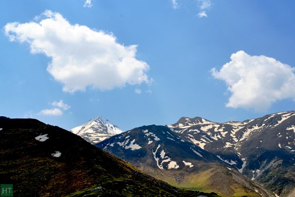
Today is a long day as we started at 6:30 from Dakwani and ended the day at Auli campsite at 5:15 in the evening. I woke at 5:00 and started to get ready. Meanwhile Dev and Sheroo were busy preparing breakfast. It was planned that we would be having breakfast on the top of Kuari Pass. We started from Dakwani at 6:30. Dev and his team were to pack camp and join us on the pass. The trail from Dakwani goes straight over level ground for around two hundred meters and then begins to climb on the ridge above the campsite in a zig-zag fashion. We reached the bottom of the steep climb to the pass relatively fast. In here one feels surrounded by awe inspiring tall and ridged steep cliffs. Soon the trail became steep and our pace slowed down. We took occasional breaks on the steep ridge. The pass can be seen as an arc on top. It looks deceptively close but is actually still far away. We spotted a Himalayan Monal on the adjacent ridge looking at us bewildered. They are brightly coloured especially the male ones and are the state bird of Uttarakhand. It took us an hour and twenty minutes to reach the top by around eight but sadly the sky was not clear and was hazy. But yet, we could see that the whole skyline up ahead was composed by majestic snow clad peaks. These are some of the tallest peaks in Garhwal Himalayas and in India. Kamet, Neelkanth, Hathi-Ghoda parvat, Chaukhamba etc are some of the major peaks partially visible today. Meanwhile the team of Dev had also reached the pass. The pass is marked by a cairns where we offered a small puja and also shared prasad. We then had breakfast of puri and subzi.
It is very windy on the pass and we fastened our wind proof jackets. The trail from here goes in an arc over the ridge in a narrow path. If you are doing this trek at end of summer (late may/ early June) you may find patches of snow on both sides of the trail. It is common to find local villagers on the slopes searching for a type of herb called Kida Jadi which is rare but fetches good money due to its medicinal value. On the other side the trail goes downhill for almost three hundred feet and follows the semi circular path. The trail is often crossed by small threads of running water from mostly the melting of snow patches on the adjoining ridges. After a while you need to cross a small stream over boulders. Now on both sides of the trail beautiful bugyals stretch for miles with flocks of sheep and goats dotting the landscape, a feature typical to Garhwal and Himachal. Behind you Pangarchula rises like a magnificent pinnacle of ice and snow and in front dominating the skyline is the famous peaks of Garhwal Himalayas. Look for a clearing on your left below the ridge surrounded by a row of trees. This is the lovely campsite of Khulara and on the way to Tapovan. The trail continues in a couple of rocky spur with a depression in between lined with thick grass. It opens to the flat meadow of Chitrakanta, another convenient place to camp. From here the trail descends and enters the forests of oak and conifer.
Continue on the trail through the wilderness traversing through the mountain slope. The trail through the forest continues for another hour and at the other end the forest ends into the small lake of Tali. This lake serves as the only source of permanent water and it is common to find flocks of sheep clustering around its banks. From here the trail goes up roughly fifty feet in a steep ascend and levels to a flat grassy plain. We took a break here as it was time to have lunch. From here the trail divides into two paths which merge with Gurson bugyal. The broader trail goes over the ridge top and descends to the bugyal of Gurson on the opposite side. Another trail which is narrow traverses the ridge instead of going over it and meets with the other at the start of Gurson bugyal. However ponies cannot negotiate the narrow track. We followed the narrow track which at places is no more than a foot wide with almost vertical cliff on one side and the steep valley on the other. We walked slowly taking support of the cliff side. There are boulders on this stretch that one needs to cross over. Any slip of the foot at this point can land you hundreds of feet down into the valley floor and even the courageous heart skips a beat. After 45 minutes the trail ends into the magnificent bugyal of Gurson with miles and miles of rolling green carpet all around.
There are numerous small flowers dotting the landscape of the bugyal and in the horizon the snow peaks can be seen with Nanda Devi dominating the skyline. The lovely walk over the bugyal is an experience to remember. It is very windy and is another 3 km to Auli top. From Auli top we descended almost six hundred feet to the campsite of Auli. After four days of trek in remote Himalayas we were again back into civilisation. We pitched out tents and had dinner and went inside the comfort of sleeping bags exhausted and drained out.
Day 7: Auli to Haridwar, 13 hours
Today was going to be a long drive back to the nearest rail head Haridwar. We bid farewell to the mule men and packed our logistics into the car and drove to the cantonment town of Joshimath where we had breakfast and reached Haridwar by 6:00 in the evening. I know that soon I will get into the coding and decoding of software but the memories I will cherish forever.
Comments