A fire is lit mostly with alpine shrubs. The flame is swaying wildly with the veering gust. The bushes produce more smoke than flame. Occasionally when it catches a few dry twigs, the flame leaps up into the air in an attempt to catch a breath of fresh air. When the flame leaps up, it chases away the shadows surrounding us. In an instant though the shadows come rushing back and crawl up our backs. The lean, sharp features of Chattan Singh, Uttam Singh, Bipin, Ramesh crowding close around the fire look handsome in the flickering light that hides more than reveals. The hollow in their cheeks, the sunken eyes hide in their own shadows. In the broad daylight they look unkempt in worn out, tattered clothes, soiled in the mountain dust, brushed and bruised against the raw nature for days. Their attires look oversized on their lean but brawny structures. In this shimmering glow they are legendary men from medieval age on a secret royal mission. Their jaws are tight in determination, their eyes glint as they look into the fire and dive into their experiences to narrate one story after another of various events and exploits in these mountains, stories that seem brushing with death to us, with placid indifference. Knowing not how to respond, we laugh, more in awe than in appreciation. In between they go and fetch water from a stream, some go and cut more bushes to feed the fire, some go and help Bipin with his cooking. Chattan Singh jumps up on a big rock and parches himself there. Their agile moves exude confidence bred from supreme familiarity with these mountains.
They put their hands against the fire, sometimes inside the fire momentarily to draw the warmth. So cold are the clothes that the fire doesn’t catch on immediately. Uttam Singh, sitting on his haunches for long, stokes the fire with some branches cut from juniper bushes. The flame sways dangerously close forcing us to leap back.
Dinner is served around the fire with the accompaniment of anecdotes by the crew and music playing on mobile phones that are surviving on the fourth night on life support from a portable power bank. In due course a full moon circled over the mountains and cast an amazingly clear spell of silvery light in the scene. After a brief interval post sun down, the whole scene was lit up again and all the colours aligned themselves in varied shades of silver, grey, white and darkness.
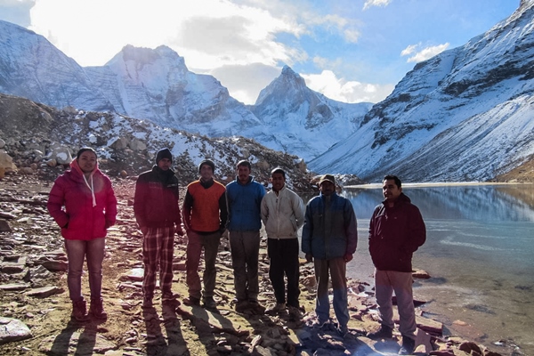
We have camped halfway in between Kedarkharak and Bhojkharak on our way back from Kedartal. Ramesh ji, hence forward our guide, has caught up with us here coming up from Gangotri today. Gokul ji, who has been guiding us so far on our Kedartal trek would be leaving us tomorrow. It was Ramesh Ji’s suggestion to camp there instead of attempting to cross the rock fall zone in the late afternoon hours. The past three days saw us ascending to a height of approximately 16500 feet as we marched on towards our destination, the majestic Kedartal.
On our way to Gangotri from Haridwar we stayed for a day in Uttarkashi where Gokul ji and Ramesh ji met us to finalize all arrangements. Next day we stayed at Gangotri in the GMVN guest house that overlooks Suryakund, a place where Bhagirathi plunges some 30-40 feet through the rocks. Steeped in interesting mythological anecdotes, even for people like us who are not much religiously inclined, these places assume a character that transcends a mere natural phenomenon. Gangotri surprised us with the nip in the air.
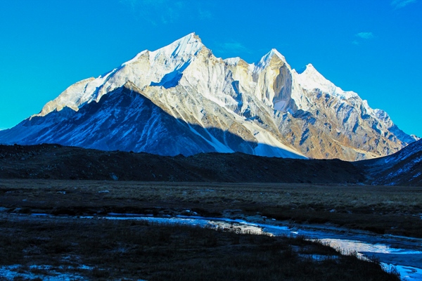
Trek to Bhoj Kharak
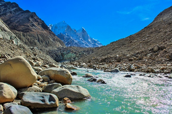
Our first day of the trek to Kedartal started around 9 in the morning from Gangotri. The trail snakes along in sharp twists through a forest of pine, fir, birch and maple. We were gaining altitude rapidly. Soon Gangotri appeared a distant settlement down in the valley. Our path followed the course of the narrow Kedarganga gorge. Even when Kedarganga is lost in the depth of the gorge, relentless throttle of the river working her way down below in the chasm funnels up the mountain. It’s an abyss of a canyon, such a sheer drop that those having vertigo can feel dizzy at times. The narrow trail moves along precariously clinging to the face of the mountain.
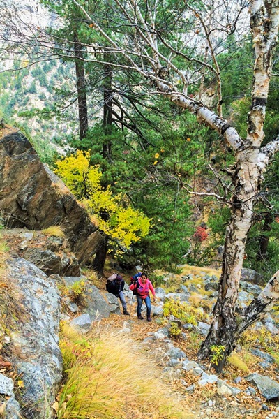
That time of the year the grass was yellow with the early advent of winter at high altitude and the scorching of the sun. The birch trees, which soon began to dominate the others, had shed their leaves and were standing like bare skeletons with outstretched boughs, their silvery barks peeling off from the trunks. At Bhojkharak out tents were pitched a little way down from the trail in a small cup like glade. It provided some shield from the gale sweeping the ridges and upper meadows.
Trek to Kedar Kharak
The trek to Kedarkharak started again around 9 next morning after a filling breakfast. With a varied menu at our disposal comprising of simple dal, chawal, sabji, roti to Pan-cake, alu paratha, pasta, soup, an abundant supply of chocolates and toffees, innumerable rounds of steaming hot tea with tasty additions to it and limited shots of hard beverage in the evening; food for one thing was not compromised albeit all other material comforts were perforce forsaken. Everyone was taking it easy as the distance to be covered on each day of this trek was not great although it involved steady and at places rather steep uphill slog.
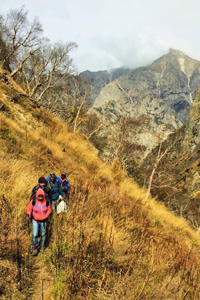
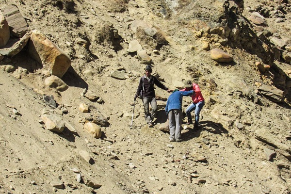
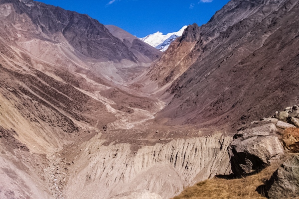
The more we advanced towards Kedarkharak, more the mountains became bereft of trees. Red shrubs and burnt grasses dominated the scene. Pinnacles of rugged rocky mountains closed in from our left almost to a claustrophobic effect while the path sticks to the true left of Kedarganga. At one place the trail ceased to exist. A huge landslide had eaten away the face of the mountain. Before we could get much bewildered as to how we were going to negotiate that stretch, Chattan Singh grabbed my hand and started pulling me down over loose and infirm near-vertical slope. Every now and then small rocks were tumbling down leaving behind a trail of dust. Anik and Anwesha followed led by Uttam Singh and Bipin. All the while Gokulji was looking up at the mountain from the river bed and signalling the crew when it was safe to pass. With much effort we descended to the river bed and proceeded along the bank of Kedarganga over boulders till we passed the rock fall zone. Then we clambered up to resume the trail again.
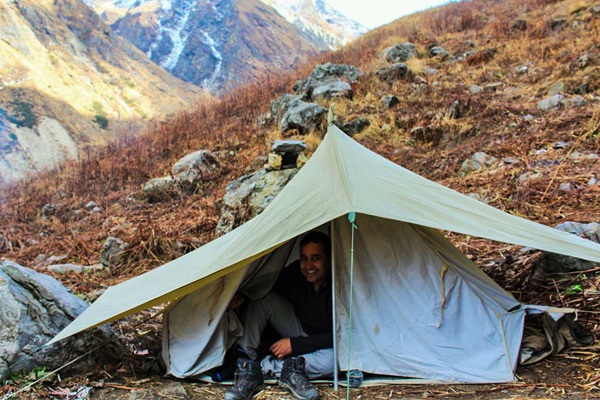
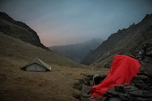
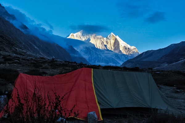
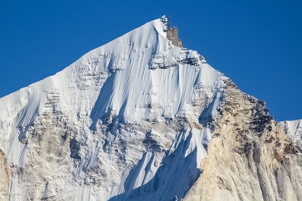
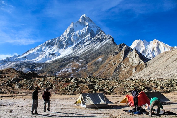
As we came up on the trail, the majestic peaks of Thalaysagar, Bhrigupanth, Manda groups began to peak over the glacial moraines in the distance. Our tents were pitched on the nice rolling meadows of Kedarkharak. In the evening we all gathered in the kitchen tent for warmth. It was not possible to do a bonfire here as the meadows do not encourage growth of much shrubs. The kitchen tent, built with a single piece of tarpaulin anchored on one side of a big rock which was leveraged as a side wall, was the only place to settle down for the evening.
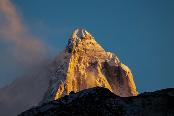
I came out of the shelter at the right time. The sun began to set on the meadows of Kedarkharak; dusk was descending. The Thalaysagar peak stood out like a golden temple of our pilgrimage with intricate carvings on the facade. A tinge of crimson on the tip of Bhrigupanth and the whole incandescent peak of Thalaysagar stood out from the rest of the peaks and the meadows rolling away into the glacial moraines in the distance that plunged into semi darkness.
These shivering evenings, the chit chats with the crew around a fire or crowded in a tent over cups of hot corn soup, multiple rounds of tea, popcorn, chanachur add a special taste to the whole experience. This is when the paradigm shift from the daily chores of our life to this nomadic mountain life really sinks in. It is in one of these after dark gatherings that we came to know how Ajit Singh came to be christened as Chattan Singh. There was an avalanche in one of his treks. He made sure that the trekkers got away from the path of the debris but found himself caught on the path of a big rock hurtling down straight at him. Finding no other way to escape he slid down the steep snow covered slope on the hillside and eventually got stuck in a crevasse that probably saved his life. He was rescued from the crevasse by the elder brother of Ramesh ji who was guiding the team then. Many other stories, stories of mishaps, stories of fortunate escapes, stories of expeditions to various peaks, they had an unending repertoire.
Because of the wide open meadows, the weather in Kedarkharak was harshly cold. On our way to Kedarkharak we met the solitary group returning from Kedartal. They reported a temperature of minus twenty degrees at Kedartal because of which presumably they could not camp there. They wished us best of luck. We were too preoccupied working our way up to ponder over whether what they said about the temperature was an exaggeration or if that was the exact reason they could not camp there.
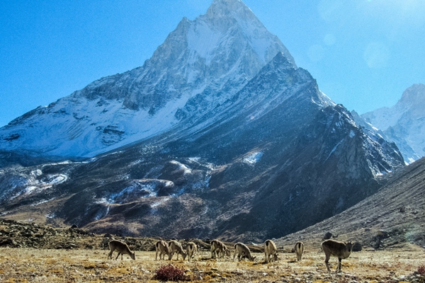
The yellow billed Choughs and the Bharals showed their resilience in putting up an appearance in representation of their respective avifauna and fauna species on the meadows while the sun lasted. As the sun began to set even they didn’t brave the surge of cold wave.
Trek to Kedartal and camp
The final five kilometres from Kedarkharak to Kedartal is strenuous. It involves crossing multiple rocky ridges over glacial moraines. As there is no fixed trail over the moraines, finding a path over a terrain strewn with large rocks may be daunting. There are cairns placed at some points to provide a rough idea of the route to follow. Because of glacial activity the path keeps changing. Gokul ji pointed his finger to a gaping crevasse that has opened up at a place where the earlier trail used to pass. A number of times we trudged up a ridge laboriously expecting to see Kedartal on the other side from the top only to find another series of ridges interspersed with rocky terrains still to be traversed.
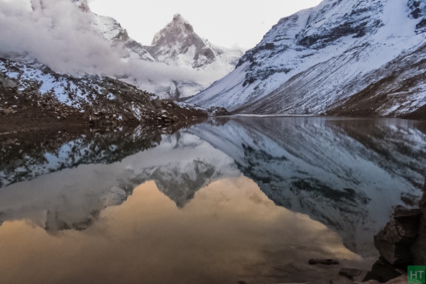
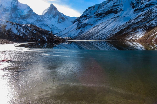
On the last ridge before Kedartal we scrambled up the rocks on the steep face of the ridge for about a hundred metres and then finally Kedartal revealed itself as a medium sized turquoise lake nestled amongst Bhrigupanth, Thalaysagar, Jogin group and a moraine ridge that goes towards the Jogin advanced base camp. We descended the ridge on the other side again for about a hundred meters to the shore of the lake, the unperturbed crystal surface of the lake mirrored Thalaysagar and Bhrigupanth.
The night temperature at Kedartal was such that the moisture from our breath froze inside the tent and we woke up in the morning to find the inside of the tent lined with a thin layer of frost that smeared our jackets and caps as we sat inside the tent. Surface of the lake near the shore was covered with a thin transparent layer of ice. Throughout the trek we were fortunate to have nice crisp and clear weather which accounted for no major snowfall. Bipin offered puja to a sacred rock and put tilaks on our foreheads. We started on our way back at a leisurely pace.
While returning from Kedartal we camped between Kedarkharak and Bhujkharak, and next day we reached Gangotri. We relaxed at Gangotri for a full day before walking to Tapovan.
Tapovan
If the name Raktavan didn’t send a chilling shiver down our spine it’s largely because the spine had by that time grown quite intolerant of shivers! As the name suggested, it did indeed look reddish. Rameshji clarified that from July to September, fed by the monsoon rains washing the meadows of Raktavan, the nala that gushes down and empties into Bhagirathi assumes the colour of blood. The Raktavarn glacier is one of the main tributaries of the Gangotri glacier.
Standing on the Gangotri glacier we could see a team heading towards Raktavan. Somewhere from high above on the barren mountain, rocks tumbled across their path. The team stopped for a little and then hurried across the path. We also crossed a rock fall zone between Chirwasa and Bhojwasa. Clear instructions were given by Rameshji to keep looking up to watch out for falling rocks and cross the zone as quickly as possible without stopping. Stopping was allowed only if the hillside was overgrown with grass which binds the hillside like a wire mesh. On a barren slope of loose soil, rocks lurk waiting for that moment to succumb to gravity. For some large precarious looking rocks, that moment seemed to have frozen as they hung in delicate balance providing opportunities for overgrowth to firm up the ground.
Till Gomukh we were accompanied by co travellers. Many of them were pilgrims, the others just tourists. All had the common objective of witnessing the holy river start her long journey where she is at her holiest and purest. Compared to Kedarganga, Bhagirathi flows through a much wider and open valley that receives plenty of sunlight which accounts for the dazzling fall colours.
The 18 kilometre stretch from Gangotri to Gomukh is comparatively easy striding over a gently ascending path curved out for the hordes of tourists many of whom are past their prime. Not all tourists finally make it to Gomukh though. Some ride on horseback. Some, unprepared for undertaking the journey on foot through lack of experience of a Himalayan trail, become overcome with fatigue midway and head back. A Bengali group comprising around a dozen members whom we passed at various stages en route was represented by a single person at Gomukh, the others having abandoned the endeavour somewhere before Chirbasa which is around 10 kilometres from Gangotri. The various reasons that could be attributed to why they should not be able to reach camp at Bhojwasa by evening, despite the path being a descent one, was dominated by a single glaring one; unpreparedness.
Past Gomukh there is hardly any human intervention on the trail. It’s all rugged glacier country that admits only the rule of nature and human must find and follow the path charted out by nature. Once we started moving up on the glacier, only co travellers that remained were a few porters heading towards Vasuki taal to assist an expedition on Mount Satopanth.
After crossing Gangotri glacier diagonally from true right to true left, it’s a scramble over rocks on near vertical face on which we tried to follow a zig zag path to give our thumping hearts a fighting chance to stay where they are and not burst out. Having done Kedartal first we were more than adequately acclimatized and perhaps our hearts grew used to doing all the thumping and beating, with the body, perforce, not paying much attention to those manoeuvres. In the end it didn’t turn out to be quite as imposing as it seemed standing on the middle of the Gangotri glacier. When we were pointed to the slope from Gangotri glacier, it called for suspension of disbelief to trust that we would be negotiating it without any rope or any equipment. However, once on it, a trail seemed to be forming out of nowhere by connecting the footsteps of Bipin whom I was following closely. Less than an hour’s slog and we were ambling around on the flat meadows of Tapovan.
Sneaking up at snail’s pace, so as not to alarm them into a flurry, to within fifty feet to the blue sheeps grazing peacefully at the base of Mount Shivling, getting down on the ground to get a wholesome shot with the imposing mountain in the background, digging the camera out from the rucksack, assembling it and finally having managed to get a few shots captured, I realised my legs were not in that great shape to support myself in that kind of posture for long. I dragged myself up with much effort, and rambled along the grassy trail towards our camp. The mattresses were laid out on the lawn and I sat upright with folded legs in keeping with the meditative atmosphere with the crispy sun on my back. Alu paratha and spicy pastas were soon at our service followed by hot black tea. Be it hot or heard, a beverage is next to nothing when it comes to complementing tranquillity, particularly the tranquillity imposed and accentuated by the montane surrounding and weather.
A lady monk draped in a cherry red attire came nimble-footed across a small ridge and revealed herself to be of foreign origin. Uttam Singh clarified that she is German. As she walked across to a stone hut on the other side, her fluid gait exuded an athleticism typical of those used to traversing the Himalayan terrain for long.
Tapovan is a surprisingly flat meadow at close to 4500 metre altitude roughly the size of some 7-8 football grounds flanked by Gangotri glacier and Bhagirathi peaks on one side and overlooked by Mount Shivling on the other. Meru peaks can be seen beside Shivling just a little distance away. The entire prominence of Mount Shivling is the most spectacular sight to behold in Tapovan. Walking right up to the base of Mt. Shivling is like a leisurely walk in a large garden. A half frozen stream coming down from the glaciers of Shivling and Meru was flowing across Tapovan. Evidence of other glacial streams in the form of boulders and pebbles strewn along the path of where the streams used to be in the rainy season could be easily discerned. In the season when glaciers melt and rain comes lashing, a multitude of streams criss-cross Tapovan, rolling out a lush green carpet, before finally descending onto the Gangotri glacier.
Next morning saw us climbing another steep moraine ridge to Neel Tal, something around 200 to 300 meters above Tapovan. The extra oxygen of early morning coupled with the thorough acclimatisation we had undergone made it a fairly easy climb. It was the eighth day of moving up and down, mostly up, in this region. Neel Tal turned out to be just a void, a small area of depression with a few patches of snow. All the water had dried up. The ridge however commands a comprehensive view of the topography of Tapovan. Tapovan seemed like a huge field at which we were looking down from the upper tiers of a giant stadium. Gangotri glacier stretches away towards the Chaukhamba peak in the distance, partially visible through the gap between Bhagirathi peaks and Shivling. Numerous crevasses can be seen on the glacier looking out from the glacial debris. One has to go down to the glacier and climb up on the other side to reach Nandanvan which can be seen at the base of Bhagirathi peaks. Meru peaks, completely outshone by Mount Shivling when viewed from Tapovan, appear more prominent from here. All these surround the impeccably flat terrain of Tapovan, partly bisected by a single small ridge around which we went the previous evening to walk right up to the base of Mount Shivling.
On our return from Tapovan we stayed at Chirbasa which is a small forest of Blue Pine, Silver Fir and Spruce, an afforestation initiative. We could have come all the way back to Gangotri but the crew would have had to stay back at Gangotri that day requiring accommodation. We deliberately walked slow deciding to enjoy one more night chit chatting by the bonfire.
All photos are shared by author.
Comments