
Sandakphu–Phalut Trek: Classic Ridge vs Forest Trail – Which One Fits You?
Sandakphu (3636 m) and Phalut (3600 m) offer something few Himalayan walks can match: a balcony view of four of the world’s five highest summits—Everest, Kanchenjunga, Lhotse, and Makalu—lined up on one skyline. Yet in recent years the question has shifted from “Should I trek to Sandakphu?” to “Which way should I go?” Two distinct options now exist:
- the time-honoured Singalila Ridge that threads tea-house hamlets along the Indo-Nepal crest
- a quieter forest route via Rimbick that trades sweeping vistas for deep pine and rhododendron woods.
Below we unpack the facts, characters, comforts, and compromises of both so you can match the trail to your priorities.
Why the fork in the path?
A metalled road now reaches as far as Gairibas and Kaiyakata, and the dirt road continues to Sandakphu. Jeep traffic, peak-season “touristy” crowds, and noise have nudged many trekkers to hunt for solitude.
That quest birthed the alternative forest approach, still blissfully free of tourists and roaring Landrovers.
Important Notes:
The motorable road has been present for ages (at least since the 1970s) to Sandakphu and even till Phalut. However, in recent times since post-Covid, car-sightseeing tourists have increased manyfold. As of 2025, cars are allowed only till Sandakphu and no further to Phalut.
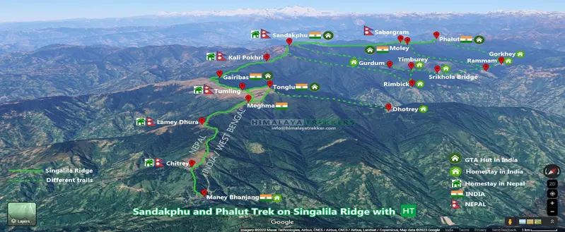
1. The Classic Singalila Ridge Route from Maneybhanjung/Chitrey
Route outline
Manebhanjan → Chitrey → Meghma → Tumling (Optinal via Tonglu) → Gairibas → Kalapokhri → Sandakphu → Phalut → Gorkhey → Rammam → Srikhola
As the name suggests, this trail is on the Singalila Ridge itself that divides the two countries, India and Nepal. You stay in a mix of tea houses, trekkers’ hut and a few homestays.
We have two variants on this Ridge route , the more popular being the shorter Sandakphu-only trek that takes a downturn from Sandakphu and descends to Srikhola via Gurdun and Timburey. The other is the longer Sandakphu and Phalut trek that stays entirely on the ridge till we reach Phalut. Then we descend via Gorkhey and Rammam to Srikhola. So both the variants eventually end at Srikhola, the latter being a longer loop.
Here is a map with inforgraphics highlighting the ridge route and surrounding area. You are walking directly towards the high mountains on this route.
What sets it apart?
- Panorama overdose – ridge-top walking means horizon-wide views on both flanks almost every day. Even the shorter variant offers ample viewpoints like Chitrey, Tumling, and Tonglu (optional for Indians, a must to take route for foreigners) and stretches on the motor road itself.
- Border ballet – you step in and out of India and Nepal without noticing until the signboards switch.
- Tea-house rhythm – warm beds, momos, and millet brew appear at civilised intervals.
- Spring bloom – rhododendrons and magnolias splash the slopes; red-panda sightings aren’t unheard-of.
Perfect for you if …
- It’s your first multi-day trek or you’re travelling with family.
- You don’t want to take chances with the mountain views; here you get mountain views even on the approach days.
- A safety net matters: vehicles can still reach you for an evacuation.
- Group departures and budget tea-houses suit your planning style.
Mind these downsides
- Roaring landrover engines & noise on certain stretches, especially after the recent tourist influx
- Crowds during long weekends, festivities and holidays season.
- Ecological strain—litter and honking unsettle the fragile ridge habitat.
- Foreigners/Non-Indian citizens can’t enter into the Nepal side tracks or trails, nor can they stay in lodges which are in Nepal.
Our take: Avoid long weekends and peak festive and holiday seasons (e.g., Durga Puja/Dussehra, Diwali, Christmas and New Year, etc.); you will get the most out of the classic Ridge route. Beginners or those who seek a bit more comfort should stick to the shorter Sandakphu-only variant, as you miss not much from the views perspective while keeping it an easy, enjoyable walk.
2. The Forest Route from Rimbick/Sepi/Srikhola
Route outline
Rimbick → Gurdum → Sandakphu → Phalut → Gorkhey → Rammam → Srikhola
The idea of this route is to bypass the motor route altogether and make use of the forested trail as much as possible. So instead of following the ridge route here, we approach Sandakphu, following a forest-covered trail from Rimbick to Sandakphu, then stay on the ridge from Sandakphu to Phalut and then again get down from Phalut through the forest, as Option 1 follows.
Here is route map with other information for the forest route.
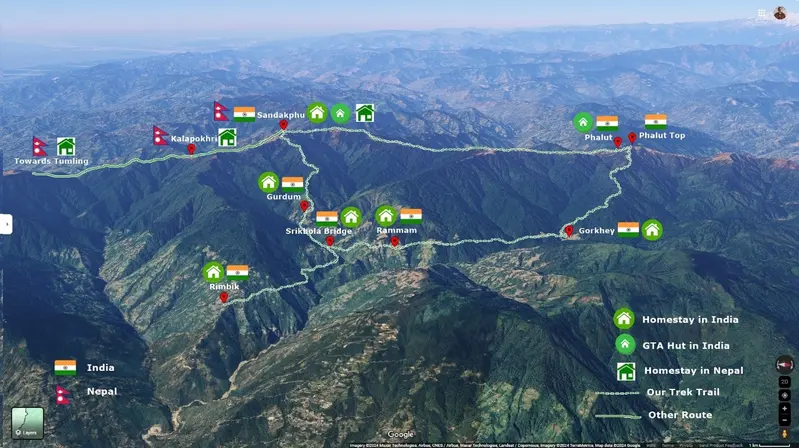
Some companies flip our forest itinerary on its head—starting from Srikhola/Rimbick, pushing north to Phalut, then marching south along the ridge to Sandakphu before dropping to Gurdum and back to Srikhola. On paper it looks neat; on the trail it’s awkward. Between Gorkhey and Phalut there’s no roof for the night (similar constraint as our route does), and inserting a stop at Moley (which is 1 km down from Sabargram inside the forest; check the image below) merely breaks rhythm without adding comfort. More importantly, the signature skyline of Everest, Lhotse, Makalu, and Kangchenjunga sits behind you for the entire Phalut-to-Sandakphu stretch—like trekking with the curtains closed for balcony views!
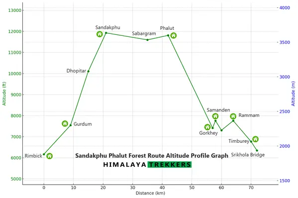
Check the altitude profile vs distance graph to get a visual representation of our proposed forest route direction. Note that there is no intermediate place to stay or camp between Gurdum and Sandakphu apart from a lone tea stall at Dhopitar for a chai-yai yai noodles break.
What sets it apart
- Silence—no engines, just thrushes and flycatchers, rustle of pine needles.
- Workout factor—steeper pulls after Gurdum test the quads.
- Immersion—mossy trunks, birdlife, and local homestays far from tourist bustle.
- Simpler permits for foreigners —less paperwork here, and the trail doesn’t cross the international boundary into Nepal.
Perfect for you if
- You’ve trekked before and crave seclusion over constant vistas. You do get magnificent view from Sandakphu, Phalut and the stretch in Between when you walk on the ridge.
- A tougher gradient feels like a feature, not a bug.
- A custom, private itinerary fits you or your group better than fixed-departure tours
Mind these downsides
- Fewer long-range mountain views until the Sandakphu day
- Sharp sustained ascents—not ideal for beginners or even for the experienced ones who are not fairly fit.
- Limited emergency options—no quick jeep bailout until you re-join the ridge.
- No fixed group departure treks but only customised treks.
Our take: Take this route only when you are an experienced hiker with a fairly high level of aerobic fitness. Moreover, it suits better if it is a strict no-no to see a jeep crossing by on a hiking trail!
Choosing the Right Route: Key Considerations
Rather than rushing the decision, weigh these factors against your own priorities and trekking history:
| Decision Factor | Classic Ridge Route from Maneybhanjung | Forest Route via Rimbick |
|---|---|---|
| Daily Scenery | Wide-angle Himalayan panoramas from Day 1; sunrise and sunset on four 8 000-ers. | Enclosed pine and rhododendron forest until Sandakphu day; views arrive as a finale. |
| Gradient & Effort | Gradual ridge climbs with frequent tea-house stops; ideal for first-timers and mixed groups. Either an easy-grade trek to Sandakphu or a moderate one when you add Phalut to the itinerary. | Sustained, steeper pulls after Gurdum; best for trekkers with prior multi-day experience. A moderate to difficult climb from Gurdum to Sandakphu in a single day. |
| Trail Atmosphere | Lively hamlets and occasional jeep traffic; easy access to hot meals and warm beds. | Quiet paths, birdsong instead of engines, simple homestays with local hosts. |
| Logistics & Safety Net | Vehicle track never far away—evacuation possible even in poor weather. | Limited exit points until the ridge; commit only if comfortable with remoteness. |
| Cultural Experience | India–Nepal border crossings and classic tea-house culture. | Intimate forest hamlets and closer interaction with local hosts. |
| Environmental Impact | Higher footfall and some dust—choose eco-lodges and pack out litter. | Lower visitor numbers mean a lighter footprint, but facilities are correspondingly basic. |
In short:
- Choose the Classic Ridge if you crave big-mountain views every day, gentle gradients, and the reassurance of road access.
- Opt for the Forest Route if you value solitude, don’t mind tougher and rigorous climbs, and prefer listening to wind through pines over walking on jeep roads.
Still undecided? Get in touch with your trekking background and travel window—our team will recommend a route (or a hybrid itinerary) tailored to you.


Comments